
Support from space
Use satellite remote sensing data to determine the differences in long-term growing conditions and current crop development.
Optimize the planning of soil sampling and analyse the reasons for heterogeneity. React and plan your sowing / seeding, fertilization and crop protection tasks on a site-specific basis and thus reduce the competitive pressure of the plants. Increase nutrient and water utilization and reduce the risk of failure.
Satellite data is the central building block for site-specific management of your areas.
TalkingFields satellite maps
TalkingFields maps are a product of the companies Vista Geowissenschaftliche Fernerkundung GmbH and FarmFacts GmbH. Vista GmbH has been collecting satellite images of biomass, location and yield information worldwide for many years.
Complex calculation and evaluation models enable the evaluation of this data and the production of TalkingFields maps. These maps provide you with precise information on the soil parameters of your land.
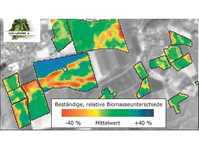
The TalkingFields (TF) base map
- Geostatistical evaluation of multi-year satellite data
- Adjusted for weather and crop type influences
- Statistically verified, consistent, relative biomass differences
- Basis for site-specific sowing / seeding, fertilization and crop protection tasks
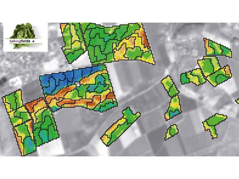
The TalkingFields (TF) zone map
- Extension of the TF base map
- Grouping of similar growth areas into digital zones
- Optimization of the sampling strategy and soil mapping
- Basis of GPS-supported soil samples
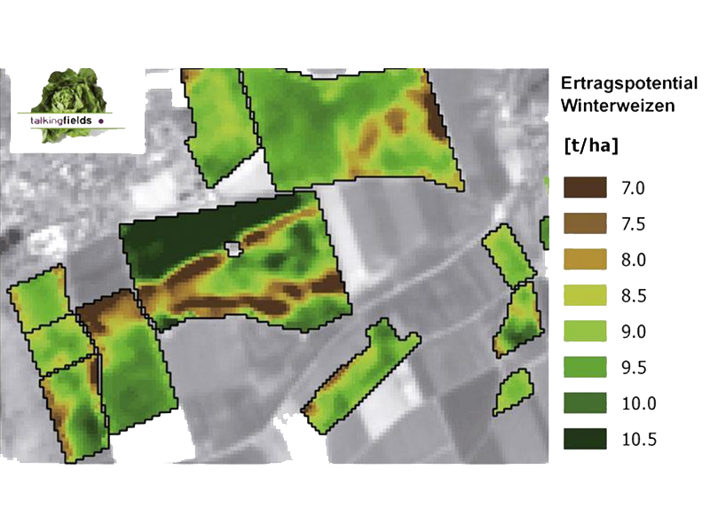
The TalkingFields (TF) yield potential map
- Yield potential of certain crop types with optimal nutrient supply
- Takes into account local soil and climate conditions, including soil type, soil type, temperature, precipitation and radiation
- Available for wheat, rye, barley, oats, triticale, sugar beet, rapeseed, maize
- Absolute values in t/ha
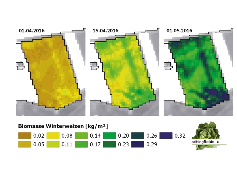
The TalkingFields (TF) biomass map
- Total above-ground dry biomass
- 4 dates per year
- For winter wheat, winter barley, winter oilseed rape, maize and sugar beet
- Absolute values in t/ha
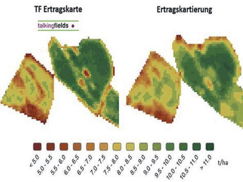
The TalkingFields (TF) yield forecast
- Small-scale yield forecast from 4 weeks before the start of harvest
- High accuracy by taking weather forecasts and long-term weather observations into account
- For winter wheat, winter barley, winter oilseed rape, maize and sugar beet
- Tested with in-situ measurements
- Absolute values in t/ha
1. identify site differences
Determine and quantify differences within your areas and stands with the help of satellite images.
2. cause analysis
Use remote sensing data to sample your soils and analyze the causes of growth variations.
3. precision farming / site specific management
Adjust sowing / seeding, fertilization and plant protection to the site-specific optimum.
4. create optimal conditions
Reduce competitive pressure and the risk of failure and improve nutrient and water utilization within your crop.
5. maximize your profit
Benefit from homogeneous stocks, reduced use of resources and secure yields.